Category:Priestergrab (Lustenau)
Jump to navigation
Jump to search
| Object location | | View all coordinates using: OpenStreetMap |
|---|
 | |||||
| Upload media | |||||
| Instance of | |||||
|---|---|---|---|---|---|
| Location | Lustenau, Dornbirn District, Vorarlberg, Austria | ||||
| Street address |
| ||||
| Heritage designation | |||||
 | |||||
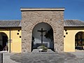
Deutsch: Priestergrab im Friedhof der katholischen Pfarrkirche St. Peter und Paul in Lustenau.
Media in category "Priestergrab (Lustenau)"
The following 4 files are in this category, out of 4 total.
-
 Priestergrab Lustenau 10092011.JPG 1,704 × 2,272; 873 KB
-
 Priestergrab Lustenau Tafel links.jpg 2,174 × 3,864; 1.06 MB
-
 Priestergrab Lustenau Tafel rechts.jpg 2,432 × 4,320; 3.58 MB
-
 Pristergrab, Maria Theresien Straße in Lustenau.JPG 3,729 × 2,797; 7.61 MB


